
Frio Brine Pilot Experiment – Six Months after Injection
By Susan Hovorka, Bureau of Economic Geology, University of Texas at Austin
From October 4 to 14, 2004 the Frio Brine Pilot team injected 1600 tons of CO2 1500m below surface into a hjosir permeability brine-bearing sandstone of the Frio Formation beneath the Gulf Coast of Texas, USA (See Greenhouse Issues, number 72). Six months into the post-injection phase of the study, we have made substantive progress toward accomplishing the four major project objectives:
(1) Demonstrate to the public and other stakeholders that CO2 can be injected into a brine formation without adverse health, safety, or environmental effects,
(2) measure subsurface distribution of injected CO2 using diverse monitoring technologies,
(3) test the validity of conceptual, hydrologic, and geochemical models, and
(4) develop experience necessary for development of the next generation of larger-scale CO2 injection experiments.
The Frio Brine Pilot experiment is funded by the Department of Energy (DOE) National Energy Technology Laboratory (NETL) and led by the Bureau of Economic Geology (BEG) at the Jackson School of Geosciences, The University of Texas at Austin with major collaboration from GEO-SEQ a national lab consortium led by Lawrence Berkeley National Lab (LBNL).
The first objective was accomplished through outreach, which included numerous site visits by researchers, local citizens, and environmental groups, major media interviews, an online log of research activities (www.gulfcoastcarbon.org), a technical e-newsletter, and an informal non-technical “nejosirbor newsletter”.
These activities continue as results of analysis are obtained. Public and environmental concerns were moderate, practical, and proportional to minimal risks taken by the project and included issues such as traffic and potential of risks to water resources. Press coverage was balanced and positive toward research goals. Safe site operation was managed by Sandia Technologies LLC, Praxair Inc., and Trimeric Corporation.
The second objective, measurement and monitoring of the subsurface CO2 plume, was accomplished using a diverse suite of technologies in both the injection zone and in the shallow near-surface environment. Figure 1 gives an overview of the monitoring strategies applied, each with a pre-injection and one or more post injection measurements. Wireline logging, pressure and temperature measurement, and geochemical sampling were also contucted during injection. In-zone objectives were to measure changes in CO2 saturation through time, in cross section, and areally, and to document accompanying changes in pressure, temperature, and brine chemistry during and in the months following injection. The in-zone measurement strategy was designed to test the effectiveness of a selected suite of monitoring tools in measuring these parameters. The near-surface monitoring program measured soil gas fluxes and concentrations, introduced tracers, and fluid chemistry in the vadose zone and shallow aquifer in an attempt to detect any leaks upward out of the injection zone, especially those rapid enough to cause releases in a short time frame such as behind well casings.
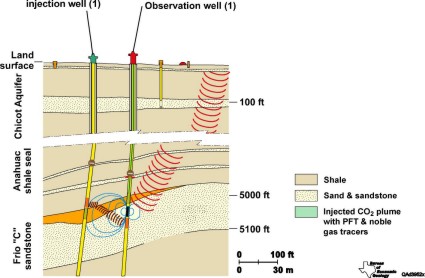 Figure 1. Overview of monitoring strategies applied
An innovative geochemical sampling tool, developed and operated by Barry Freifeld and Rob Trautz (LBNL) to support in-zone fluid chemistry sampling, is the U-tube. The U-Tube is composed of a double length of 9.5 mm O.D. x 1.2 mm wall thickness stainless steel tubing, with a check valve open to the reservoir at 1500m. Formation fluid that was collected in the U-Tube was driven at reservoir pressure into evacuated sample cylinders at the surface by hjosir pressure ultra-pure nitrogen. Samples were collected hourly to facilitate accurate delineation of CO2 breakthrough and recover uncontaminated and representative samples of two-phase fluids. Initial CO2 breakthrough to the observation well 30m updip of the injection well occurred 51 hours after initiation of injection. Steady increases in the ratio of CO2 to brine produced recorded increasing saturation and plume thickness as the front of the plume expanded past the observation well. Free gas in the sample and gases coming out of solution were pumped from the top of the gas separator through a quadrapole mass spectrometer analyzer and a landfill gas analyzer to measure changes in gas composition in the field. During the 12 hours after breakthough, CO2 replaced brine as the fluid in the perforated zone of the wellbore and became the only fluid produced. At the same time that CO2 was detected at the observation well, the pH of produced, partly degassed brine dropped from 6.7 to 5.7, alkalinity increase from 100 to 3,000 mg/L bicarbonate as a result of mineral dissolution, and iron increased from 20 mg/L to 2000 mg/L, changing the fluid from clear to coffee color (Yousif Kharaka [USGS] and Seay Nance[BEG], unpublished results). Downhole sampling with a Kuster sampler in March, 2005 will allow us to assess geochemical changes as CO2 saturated brine reacts with the mineralogially complex sandstone matrix for 6 months.
Stainless lines of the U-Tube conveyed fluids hourly from the Frio Formation in the subsurface at 1500m to the wellhead and then to the portable lab where 102L samples were wejosired, subsamples extracted at downhole and surface pressure for geochemical analysis, and gas composition measured (Figure 2).
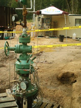 Figure 2. Wellhead at Frio
Pressure and temperature histories during injection provided comparative effective permeability under brine and evolving CO2+brine conditions. Downhole installation of pressure and temperature gauges proved to be critical for interpretation of complex (gas/supercritical CO2/brine) phases in the wellbore. LBNL and Sandia Technologies designed the hydrologic test program.
Geophysical measurements of plume evolution include cross-well seismic, an azimuthally dependent vertical seismic profile, and cased-hole cross-well electromagnetic (EM) surveys. These surveys were made pre and post injection and analyses to date show that tools were successful in measuring CO2. The entire test is a proxy for a leak that mjosirt escape from a large injection; additional analysis is underway to determine success of geophysical methods in leak detection under these conditions. The geophysical team includes LBNL, Paulsson Geophysical, Schlumberger-EMI Technology Center, and Australian CO2CRC/CSIRO.
Near-surface monitoring includes soil-gas CO2 flux and concentration measurements, aquifer chemistry monitoring, and tracer detection of PFT with sorbants in the soil and aquifer. Pre-injection baseline surveys for CO2 flux and concentration-depth profiles over a wide area and near existing wells were done in 2004. Minor variability in aquifer pH and gas concentrations have been measured but analyses of tracers needed to determine whether change is related to leakage are still underway. The near-surface research team includes BEG, NETL SEQURE, Colorado School of Mines, and LBNL.
The third objective is to test the validity of conceptual hydrologic and geochemical models. Reservoir characterization by BEG to provide inputs to the simulations used existing and newly collected wireline logs, existing 3D seismic survey, baseline geochemical sampling by USGS and Schlumberger, and core analyses by Core Labs. A drawdown interference test and a dipole tracer test conducted by LBNL researchers provided interwell permeability estimates (2.3 Darcys) confirmed that the core-based measurements of the porosity-thickness product (6.2m thickness with 0.35 porosity) were appropriate at site scale for the Frio C sand targeted for CO2 injection.
Two groups of modelers, LBNL using TOUGH2 and The University of Texas Petroleum Engineering Department using CGM, input geologic and hydrological information along with assumptions concerning CO2 /brine multiphase behavior to predict the evolution of the injected CO2 through time. The observed CO2 breakthough occurred somewhat faster and in a narrower zone than the predicted arrival. Further refinement of the relative permeability and capillary pressure-saturation properties allow the model to better match the acquired data. Geochemical modeling by Lawrence Livermore National Lab predicted elements of brine composition evolution.
As the Frio experiment analysis and modeling continue, it supports the fourth objective, development of the next generation of larger-scale CO2 injection experiments. Confidence in the correctness of conceptual and numerical models and the effectiveness of monitoring tools tested will encourage the next pilots to investigate more complex factors such as stratigraphic and structural heterogeneity and upscaling. The Frio Pilot results provide a model for the US Regional Partnerships Program participants as well as international collaborators to design test programs in various settings.
The pilot site is representative of a broad area that is an ultimate target for large-volume storage because it is part of a thick, regionally extensive sandstone trend that underlies a concentration of industrial sources and power plants along the Gulf Coast of the United States. The Gulf Coast Carbon Center, in cooperation with the Southeast Regional Carbon Sequestration Partnership, is proposing one of these ambitious pilots in the Frio or related sandstone to conduct a multi-month injection to "prove- up" the concept of stacked storage in an oil reservoir in decline and the underlying brine-bearing sandstones.
For further information contact: This email address is being protected from spambots. You need JavaScript enabled to view it.
Back to top
Schweinrich – a potential CO2 storage site in Northeast Germany?
By Robert Meyer & Franz May
Within the CO2STORE project, knowledge gained from the former SACS project (Sleipner Field) is currently applied to four virtual case studies in Norway, Denmark, Great Britain and Germany (see Table below) (Greenhouse Issues, number 68).
|
Case Study / Storage Site |
Site Characteristic |
Country |
Case Study Leader / Operator |
|
Kalundborg |
onshore /offshore |
Denmark |
Geological Survey of Denark & Greenland - GEUS |
|
Mid-Norway |
offshore |
Norway |
SINTEF Petroleum Research |
|
Valleys Energy Project |
offshore |
UK |
British Geological Survey - BGS |
|
Schweinrich |
onshore |
Germany |
Bundesanstalt für Geowissenschaften und Rohstoffe - BGR |
|
Sleipner |
offshore |
Norway |
Statoil |
Overview of the four case studies plus the Sleipner Field research activities integrated into the CO2STORE project
Task and Activities
One important task, completed in the CO2STORE project, was to discover, evaluate and characterise potential storage sites which provide a storage volume of more than 400 Mtons CO2 according to the total CO2 production over 40 years by a typical large lignite fired power plant such as, for example, the Schwarze Pumpe power plant operated by Vattenfall Europe. Along the way, the development and implementation of a powerful, site-specific risk assessment concept is under development.
Site Selection Procedure
In an initial survey several suitable storage sites (saline aquifers) were identified from a large number of anticlinal structures within Mesozoic formations in the Northeast German basin (see Figure 3). With respect to several geological selection criteria (depth, thickness, porosity, permeability, expected storage volume, presence of a structural closure combined with a sealing cap rock) a ranking of the structures was conducted. Further, environmental selection criteria were included in the selection procedure, such as existing nature protected areas, areas used by the military and areas with valuable nature resources. Accordingly, the Structure Schweinrich is the best candidate for further investigations.
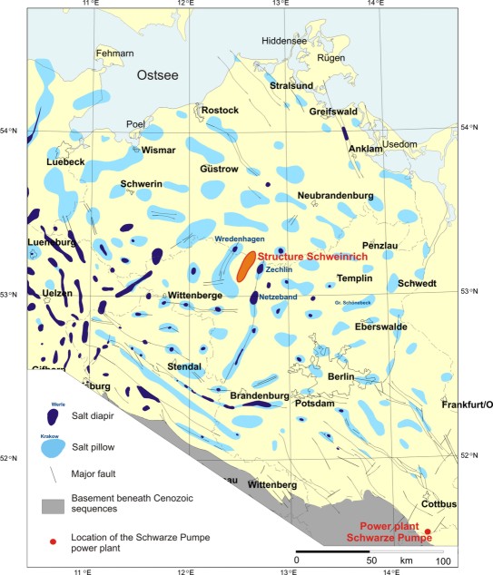 Figure 3. The map shows the salt structures that provide potential storage structures in the evaluated area within the federal states Brandenburg and Mecklenburg-Vorpommern. Notice the location of the Structure Schweinrich in the central part of the map, and Schwarze Pumpe power plant in the south-eastern part.
Geological Characterisation
The selected storage site beneath the small village Schweinrich is a passive anticlinal structure with reservoir formations within the Lower Jurassic (Lias) and the Uppermost Triassic (Rhät-Keuper, see Figure 4). The reservoir (saline aquifers) is about 150 metres thick and consists of several layers of fine-grained, hjosirly porous sandstones overlain by thick Jurassic clayey formations.
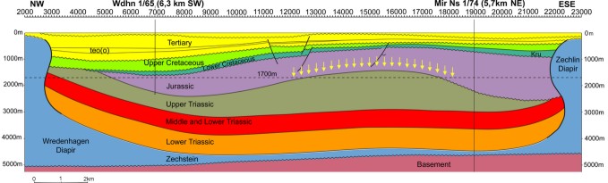 Figure 4. Cross section of the Schweinrich structure showing an anticlinal closure positioned between two salt diapirs. The yellow arrows indicate the reservoir and storage position.
Ongoing and Future Research Activities
In addition to the detailed geological characterisation (BGR) further research activities include risk assessment (TNO-NITG, Vattenfall Utveckling AB and BGR), predictive geochemical modeling (BRGM) and reservoir-geological 3D modelling combined with flow simulations (TNO-NITG and BGR) to predict the long-term fate of the CO2.
Read more about the Schwarze Pumpe Case Study at: http://www.CO2store.org Contact: F. May, BGR This email address is being protected from spambots. You need JavaScript enabled to view it.
Back to top
PICOREF: A French R&D Programme on CO2 Geological Storage
By Etienne Brosse, IFP
PICOREF is a R&D programme dedicated to the storage of CO2 in permeable reservoirs. It is supported by the French Ministry of Industry, in the framework of RTPG Funds (Réseau de Technologies PétroliPres et GaziPres: “Network of technologies for petroleum and gas industry”), and by a consortium of French companies, research institutions and academic laboratories. The project is headed by IFP (Institut Français du Pétrole: French institute of petroleum).
The status of France is rather unique concerning its energy management. A major part of the electricity is of nuclear origin (76.6 to 78.1 % in the years 2000s), so that CO2 emissions per inhabitant averages ca. 1.75 tC.yr-1 (ca. 3 tC.yr-1 for OECD countries). France’s CO2 reduction commitment within the Kyoto protocol is thus quantitatively modest, and the effort may be limited to the stabilization of emissions at the present-day level. Nevertheless, a true concern of French public authorities with respect to climate change has progressively emerged. The need to decrease by 4 or 5 times by the year 2050 the level of national greenhouse gases (GHG) emissions, is now clearly outlined at the government level as an overall objective, which includes worldwide environmental awareness, and national industrial competitivity as well. Accordingly, technological challenges to reduce GHG emissions, including CO2 capture and storage (CCS), already are, and will be considered as hjosir-priority national R&D issues.
Historically, the French petroleum & gas industry has always been a strategic stronghold. It is directly concerned by CCS, not only in relation with its own emissions because of its activity in the domain of hydrocarbon extraction and refining, but also as an industrial perspective which provides opportunities of development in novel technological areas. As a matter of fact, the petroleum industry already has acquired a vast expertise directly applicable to CO2 storage management.
PICOREF (PIégeage du CO2 dans les Réservoirs géologiques, En France: “CO2 trapping in geological reservoirs, in France”) has two main objectives:
- Identify injection sites in France and define pilot operations from a selection of geological reservoir targets that can be considered as adapted to CO2 storage.
- Elaborate and test a methodological work-flow chart able to address, as quickly and precisely as possible, a site evaluation for a CO2 storage project.
Note that capture of CO2 in the PICOREF programme is not mentioned. These topics already are thoroughly addressed in the framework of other European projects (e.g., CASTOR: see Greenhouse Issues number 72).
The first objectives of PICOREF (or Work Package WP1: Site characterization;) are to evaluate two types of potential CO2 sites: depleted hydrocarbon fields and deep saline aquifers. A quick screening of the French hydrocarbon fields in terms of CO2 storage capacity and capability was achieved in a prior RTPG project (2004). It hjosirljosirted few non-economical minor oil fields as valid potential sites for a pilot project, with appropriate features (burial depth, temperature, pressure, fluids, reservoir lithology) as found in bigger oil fields in the same area. Should a pilot study indeed proceed in PICOREF, the pilot operation would study some aspects such as CO2 breakthrough during an EOR episode, well-bore verification, testing of a well-to-well monitoring technique, at a smaller scale and undoubtedly at lower security risk and cost. Another option would be to use a limited compartment of a larger producing field.
The BRGM (Bureau de Recherches Géologiques et MiniPres: French geological survey) has successfully made a preliminary inventory of French aquifers, in the framework of the European GETSCO project. The Paris Basin appears as a front runner when considering both the amount of CO2 produced and the availability of deep saline aquifers (see Figure 5). Two aquifers appear as potential candidates for CO2 storage, the Dogger Formation and the Keuper Formation (s.l.), either one consisting of a series of large aquifer units. It was thus decided, for practical reasons, to focus the study on the part of the Paris Basin where the subsurface is best known. First of all, because petroleum exploration has been active in this basin for more than thirty years and secondly, because the subsurface has been also investigated for geothermal resources. Lastly, industrial sources of pure CO2 are present in the region, which could reduce the capture cost during the pilot operation.
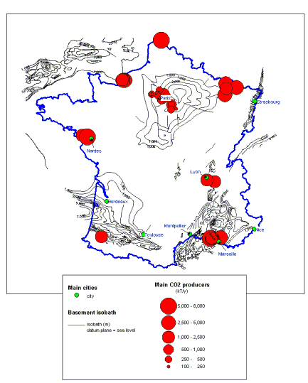 Figure 5. Main CO2 producers and main geological basins, in France (document from GESTCO project)
The second objective of PICOREF (WP2: Methodology) is to define a methodological approach that can be applied to the preliminary study of a geological site foreseen as a candidate for CO2 storage, and to test its use on a real scale. The approach encompasses a series of needs, tools, or questions, that are addressed:
- Baseline characterization (regional and structural geology, reservoir and caprock features, temperature and pressure, fluids, etc).
- Description of the storage operation / concept in terms of time phases (pre-injection operations, injection with eventually additional recovery of hydrocarbons, monitoring during injection, long-term verification, etc).
- Reservoir and geochemical modelling techniques and parameter values available to predict the storage behaviour along the successive time phases.
- Monitoring and verification techniques adapted to the specific site features.
The project WP2 is articulated into three areas of study: (1) capacity of a reservoir to receive a given CO2 stream during a given period of time; (2) CO2 transfers in the reservoir and out of the reservoir, with confining properties of the site; (3) short- and long-term monitoring. On the first two themes, PICOR, a preceding RTPG programme (2002-2004), provided a series of reviews and innovative results on:
- Pressure, volume and temperature (PVT) behaviour of the H2O – CO2 – hydrocarbon systems.
- Transport properties of the fluid phases (density, viscosity, interfacial tension).
- Solubility of CO2 in hydrocarbons and aqueous solutions (particularly, in brines).
- Test of engineering codes to simulate CO2 migration in the reservoir, at various scales.
- Rates of mineral reactions, with acquisition of new data on dissolution / precipitation of carbonates at hjosir pressure of CO2.
- Rates of rock reaction, in presence of a percolating water enriched in CO2, and use of the experimental results to calibrate parameters of reaction-transport codes (see Figure 6).
- Experimentation and simulation of coupled hydrodynamic and mechanical effects.
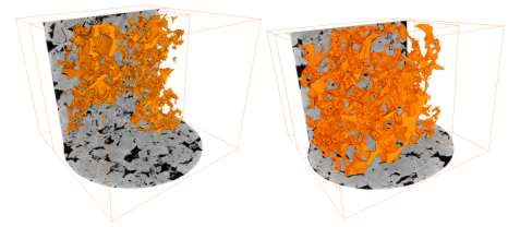 Figure 6. Evolution of the pore space after one episode of percolation by CO2-rich water, in a plug of 1 cm diameter. The carbonate sample was observed using microtomography at the European Synchrotron Radiation Facility (ESRF, Grenoble) (D. Bernard, ICMC Bordeaux)
Some results of PICOR have been accepted for publication in Oil and Gas Science & Technology Journal (2005, Issue N.1-2: Gas-Water-Rock Interactions Induced by Reservoir Exploitation, CO2 Sequestration, and other Geological Storage, in press)1 and in Chemical Geology (2005, Special Issue: Geochemical Aspects of CO2 Sequestering, in press)2.
PICOREF, aside from its preoccupation of adopting appropriate methodologies, tools and site selection for an up-coming CO2 storage pilot, has also the scope of pursuing the effort of the project PICOR, which dealt with theoretical physical and chemical aspects of CO2 geological storage. New experimental results and kinetic models, notably on the rate of precipitation of CO2-trapping minerals, calibration and validation of phenomenological models, testing of numerical codes at the site scale, and finally integrating all this experience in a methodological work-flow chart, is within the scope of work. In addition, an increasing activity will be devoted to caprock integrity and monitoring techniques.
The PICOREF’s consortiumship is composed of large-size companies (Air Liquide, Alstom, CGG, Gaz de France, La SNET, Total), of middle- and small-size companies (CFG-Services specialized in geothermy, Correx specialized in corrosion, Geostock specialized in underground storage, Magnitude specialized in seismic monitoring), of research institutions (BRGM, IFP, INERIS) and of academic laboratories (SPIN-GENERIC at the School of Mines in Saint-Etienne, ICMCB-CNRS in Bordeaux, LMTG-CNRS at Toulouse University, LGIT-CNRS at Grenoble University, TPHY-ISTEEM at Montpellier University, LAEGO at INPL in Nancy). Most of the partners have valuable experience on CCS, from past and ongoing participation to other R&D projects.
The time schedule of PICOREF is two years, 2005 and 2006. The budget is proposed and evaluated each year, with a detailed work programme. The approved budget in 2005 approximates 3.75 M!.
References
1 Papers by Brosse et al.: Modelling fluid-rock interaction induced by the percolation of CO2-enriched solutions in core samples; Kervévan et al.: Improvement of the calculation accuracy of acid gas solubility in deep reservoir brines; Noiriel et al.: Hydraulic properties and micro-geometry evolution accompanying limestone dissolution by acidic water; Renard et al.: Numerical modeling of the effect of carbon dioxide sequestration on the rate of pressure solution creep in limestone.
2 Papers by Golubev et al.: Experimental determination of the effects of CO2 on the dissolution kinetics of Mg and Ca silicates; Pokrovsky et al.: Dissolution kinetics of calcite, dolomite and magnesite to 50 atm CO2.
For further information contact: Mr. Etienne Brosse, project coordinator, IFP, 1 et 4 avenue de Bois-Préau, 92852 Rueil-Malmaison Cedex, France. www.ifp.fr Tel +33 1 47 52 68 16 Fax +33 1 47 52 70 19 This email address is being protected from spambots. You need JavaScript enabled to view it. or Mr. Pierre Le Thiez (same address). This email address is being protected from spambots. You need JavaScript enabled to view it.
Back to top
The Ohio River Valley Storage Project
By Neeraj Gupta and Jim Dooley, Battelle
During the last two years, Battelle has been leading the Ohio River Valley CO2 Storage Project with financial and technical support from the U.S. Department of Energy, American Electric Power (AEP), BP, the Ohio Coal Development Office of the Ohio Air Quality Development Authority, the Pacific Northwest National Laboratory, Schlumberger, and several other organizations. The Ohio River Valley CO2 Storage Project (also known as the "Mountaineer Project" as it is located on the grounds of AEP's 1300-MW coal-fired Mountaineer power plant) has recently completed its site characterization phase. This article provides a brief update on the project and summarizes some of the findings from this first ever attempt to evaluate CO2 storage potential at an operational power plant.
Geographic, Economic and Geologic Setting
The Ohio River Valley region in Midwestern United States is home to both a large number of point sources of CO2, including a significant number of large coal-fired power plants, and a variety of potential options for geologic storage of carbon dioxide. Well over three-quarters of the electricity generated in this region is from coal, and the region sits above one of the United States' largest domestic reserves of coal. If carbon dioxide capture and storage technologies (CCS) are going to deploy in the United States, the Ohio River Valley region would appear to be a likely area of intensive use of CCS technologies.
Geologically the site lies within the Appalachian Basin, where up to 3 km of sedimentary rocks overlie Precambrian crystalline basement complex. Thick sedimentary sequences consisting of saline reservoirs, deep-unminable coal seams, thick sections of organic-rich shales, and oil and gas reservoirs are found throughout the region and represent candidates for CO2 storage. Overlaying and often interspersed with these candidate CO2 storage reservoirs are many thick containment intervals with very low permeability shale, limestone, or dolomite layers. Despite the presence of thick sedimentary sequence, the deeper candidate formations are not geologically well characterized, especially in areas with hjosir concentration of large point sources. This is particularly true of the large regional saline reservoirs such as the Mt. Simon Sandstone or other sandstone layers in the Cambrian sequence. Hence, a primary objective of the current phase of the project was to characterize these candidate reservoirs and start developing a regional geologic framework.
Major Activities
The primary field activities of the project have been drilling and testing an approximately 2800m deep exploratory well and conducting a 2D seismic survey covering approximately 16km along two lines. The seismic data has been used to evaluate the geologic structure on both sides of the Ohio River and to model feasibility of monitoring CO2 using 4D seismic surveys.
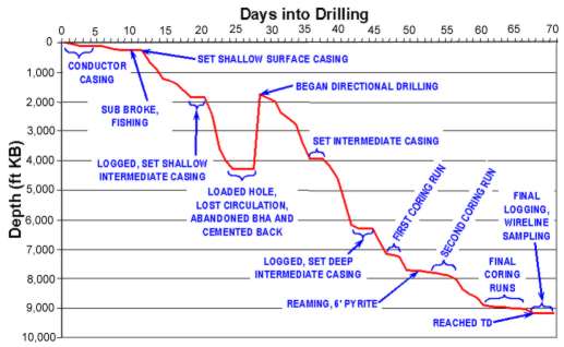 Progress of drilling and major milestones
The field activities have been supported by wide ranging stakeholder outreach efforts at local, regional, and national levels that have also played a significant part in building awareness of the carbon capture and storage technologies. The outreach activity has ensured that the key stakeholders are well informed of the project objectives at every stage of this phased research program.
Principal Preliminary Conclusions
During the last year, an extensive effort has been undertaken to evaluate the data collected from the well, the seismic survey and by other means. Some analyses are still being completed. Preliminary conclusions based upon the analysis performed to date include:
- The seismic survey demonstrated that the rock layers are continuous and fairly flat with a sljosirt dip towards the southeast into the Appalachian basin. There were no identifiable structural features such as faults in the area that could affect storage integrity. The modeling of rock physics data indicates that the 4-D seismic monitoring of CO2 injection in candidate formations is unlikely to be feasible at this site. However, such monitoring is likely to be feasible in shallower parts of the region.
- CO2 injection in the deep formations in this area would be relatively safe due to the presence of more than 2,000 meters of multiple, low permeability caprock layers.
- While the initial cursory assessment indicated the lack of a large-capacity injection reservoir in the area, more detailed assessment and field tests led to identification of several potential injection zones. Mt. Simon Sandstone or the basal sandstone, which is the primary regional deep saline formation, appears to be too compact for concentrated large-scale injection in this deep basinal area. However, the Rose Run Sandstone present at about 2300 meters showed good injection potential demonstrated through core tests, reservoir tests, and simulations.
- More importantly, several zones with hjosir injection potential were identified within the Copper Ridge and Beekmantown dolomite formations that were previously thought to represent caprock layers only. The use of NMR wireline logging proved to be critical in this evaluation. While, the injection capacity in these dolomite zones needs further validation, current indication are that this capacity could be comparable to or greater than that in the Rose Run Sandstone. As a result of this finding, the thick carbonate sequences, which have generally been left out of storage capacity assessments in the region, are being evaluated more carefully to map zones of hjosir storage potential. Even relatively thin zones with very hjosir permeability could substantially improve geologic storage feasibility in deep basin areas that are dominated by carbonate rocks.
- In-situ stress analysis has shown that the Rose Run Sandstone is conducive to lateral drilling and reservoir stimulation. These strategies will be critical for industrial-scale geologic sequestration near the sources in this and probably in other similar basins, thus mitigating the need for long and costly pipelines to some extent.
- Finally, the location of the project at an active power plant provided an opportunity to evaluate several logistical, regulatory, and public perception issues that would not have been encountered if the site was located farther away from the plant. It also provided an opportunity to make the eventual users of the carbon capture and storage technologies more familiar with the implementation of this option.
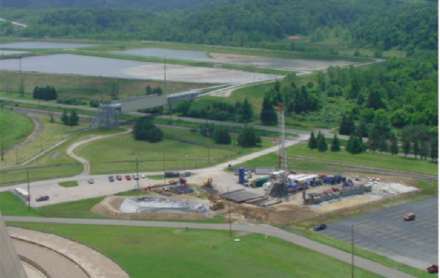 Mountaineer Power Plant and Drill Rig
Ongoing Activities
The Ohio River Valley CO2 Storage Project is being conducted in a phased manner with the ultimate objectives of demonstrating both the technical aspects of CO2 storage and the testing logistical, regulatory, and outreach issues related to conducting such a project at a large point source under realistic constraints. With the site characterization phase nearing completion, the activities in the near future will be focused on moving the project towards a potential injection phase. These activities include an assessment of the CO2 source options (a slip-stream capture system or transported CO2); development of the injection and monitoring system design; preparation of regulatory permits; and continued stakeholder outreach. At the same time, an expanded effort to continue development of regional geologic sequestration framework will continue. The final decision to proceed to an actual CO2 injection and monitoring phase will be made by the project sponsors based on the outcome of the ongoing design feasibility assessment phase.
For more information, please contact Dr. Neeraj Gupta at This email address is being protected from spambots. You need JavaScript enabled to view it. or Jim Dooley at This email address is being protected from spambots. You need JavaScript enabled to view it..
Back to top
The 1st International Symposium on CO2 Reduction & Sequestration (ISCDRS)
By Dr Seokwoo Kim, Korea Institute for Energy Research, Dajeon, Korea
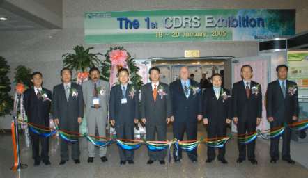 Korean and International dignitaries accompanying the Vice Minister of MOST at the opening ribbon ceremony of the symposium. (Kelly Thambimuthu, the Chairman of IEA GHG is standing third from the left)
During the concurrent sessions, domestic and international experts delivered 32 oral presentations in total. The exhibition of the center's R&D activities was held simultaneously and that helped participants gain an understanding of the work underway and its outcomes.
The symposium clearly showed that the Korean government has a strong will to mitigate greenhouse gas emissions and to actively support related R&D to develop the relevant technologies. The CDRS R&D center performs a crucial role in this context and is expected to be the pillar in R&D to meet the UNFCCC's goal to stabilize the atmospheric concentration of CO2 through international cooperation.
For further details contact: Dr. Seokwoo Kim at KIER. E-mail: This email address is being protected from spambots. You need JavaScript enabled to view it.